Parque del Lago: Campo(s) de Encuentro / Connecting Plane(s) A Competition entry by iip done with graduate students, Janette Rhee, Monica Leung, Julie Janeo and w. Pablo Molestina.
The airport, the park and the city
The Mariscal Sucre airport is a space of universality: connecting cultures; the poor and the rich; the local and the global – bringing the world down to a single line, the tarmac, in the middle of a plateau, an open field. The airport, point of arrival for Quito, further sits at the point of connection of mountain and valley, perched on the side of Pichincha. While running north-south almost at the crossing point of the hemispheres, it creates a discontinuity in the city fabric in the east-west direction, which cuts unhappily into the city fabric. The airport is set at the point of connection of Sky and Valley, at 2800m above sea level it sits below the Mountain, which rises up to 4500m, and above the nearby central valley at around 2000m. Pointed in the north-south direction, the airport practically straddles the globe‘s hemispheres. Mariscal de Sucre Airport connects Quito, the city in the clouds, vertically with the earth and horizontally with the rest of the world.
The new park is rooted in this present reality. Divisions and alienation, stratification both cultural and economic, isolation and frustration, are aspects of a daily reality which lies underneath the surface of the city. This reality is a good foundation for a great people’s park. Physical elements of the current airport, especially the great open spine running in the north-south direction, are preserved and strengthened through trees and programming. The new Parque del Lago is for the use of citizens of all walks of life, a beautiful place for rich and poor, a place of welcome, support and solidarity. Individuals and families, alongside neighbourhood groups, schools, sports clubs and associations of all kinds, find space here and interact with one another.
A plane of physical connection:
All paths, walkways, and streets of the surrounding neighbourhood are extended into the park. The East-West direction of the Landscape becomes open through the Park. In the middle, the existing landing field becomes a spectacular, generous, open space for all. Pedestrian access is universal. The airport split the city in the long axis. The Parque del Lago heals this deep discontinuity and connects the city from high to low again, in the east-west direction, from the mountain to the Valley.
A plane of social connection:
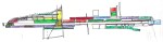
The centre of the park, the linear structure along the tarmac, is an open linear space open to everyone at any time, accessed directly from the Avenida de la Prensa, the Calle Amazonas, or the 10 de Agosto.
The network of paths behind this central space defines a network of rectangular blocks, which are defined as semi-private domains through earthen walls. These Blocks may contain fruit gardens or flower fields, or they may be divided up into parcels, which are to be be used by the community or community groups over a period of time as needed. On the basis of Social Merit, the use of these parcels may be allowed to particular groups over a period of time. Sports associations, Schools, or Special projects can use the parcels within the structure and find home here which radiates into the entire city.
City: Extend the existing urban fabric into the new park. Create a public circulation network connecting the park with all the streets and blocks of the neighbourhood. Create a below-grade east-west vehicular traffic emerges in the area of the congress centre. It becomes an underground passage only under the portion oft he central park, about 100 m long. The current artery connecting the Avenida de la Prensa with the entrance oft he airport will be reduced in importance and volume, thus improving the quality of the urban pattern on this neighbourhood.
Architecture: The conference centre, The main surfaces of the conference areas are elevated to access the upper level of the building, providing spectacular views in the north-south direction. On the ground level cafes and restaurants, open to everybody
parking and main services are in the lower level, accessed (city )through the underpass.
The airport museum at the site of the old terminal and the mural of Galo Calcio on view
in the vicinity of the park, with access to all the facilities and exhibits (aeroplanes, the history of flight, the first crossing oft he Andes etc. as seen in the mural). As well Visitor Parking is placed under the trees on grade. Services and more congress Parking is placed on the underground level, accessed from the east-west vehicular connector from underground.
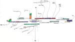
Park & Public Space: Intensify the spatial structure of the current airport condition as a VOID but one that can be public green space for the city. A strip of public land, 3,5 km long and over 75 m wide, with a continuous strip of green on one side, and the large asphalt strip on the other. Both these bands, green, and grey, will have a perimeter of eucalyptus tree 25-30m high promenade around hard and soft surfaces with amenities which encourage uses.
Landscape & Activities: Create amenities and specific uses on the Tarmac and the Green stripes. These range from the quiet and contemplative(walking, strolling), over group outings (grill parties, pick nicks), over informal sporting (jogging, climbing, boating, skater park) or formal sports (such as tennis, basketball, football, volleyball, etc.) Places for big gatherings such as music concerts, popular feasts, light shows, places for dances, processions and local folklore or political demonstrations, are also easily accommodated. Water bodies: the main lake at the end of the runway and pools along the way.
Create an „urban“ pattern in green. Use earth walls to define the exterior edges of the pattern. In time, these walls will be partially green, like the earthen paths of the countryside in the Sierra. Bringing the mountain landscapes into the heart of the city. The streets of the grid are pedestrian. Occasionally, service vehicles or emergency vehicles can use them.
Create These blocks in the patchwork grid, parcels within some Blocks, which will be allocated to neighbourhood groups, schools, clubs for the young and old, kindergartens, emigrants associations, migrant clubs, etc. The use of these spaces is not proprietary but temporal, on the basis of need and merit, parcels of the park within earthen walls are allocated for varying periods of time. Space is an asset to support groups of people to get on their feet and further social goals. Some parcels are not to be allocated and contain closed public gardens such as fruit trees or flower gardens.
The two ends of the project picking up on the airport function are open-ended. With the placement of the main lago/lake/pool at the northern end, to reflect the sky and the surrounding mountains at the point where the natural topography and the mountainous and ravine territory starts to descend dramatically. On the south end, the park becomes horizontally segmented and dissolves into a series of parallel bands which point to the city. Further, a vertical marker, to be appreciated from the centre of the city, is suggested for the southern block bordering the airport, so that the visual the tarmac, the city plateau is held between the mountains, and like the aeroplanes, the various elements connecting the ground with the sky. Quito is a world-renowned as the city in the clouds, neither at the level of the central valley like most other „high“ American cities, nor at the top of the mountain, but levitating, somewhere in between. This quality of Quito as a whole is also that of the tarmac of the airport, which is the physical point of connection between the vehicles of the sky and the ground. Connectedness in the north-south direction, the airport has acted as a connector with the world, the price has been the disconnection between the east and west oft he city. The cut in the fabric caused by the airport will be healed in the park.